- Experts say AI has been a ‘game changer’ in monitoring Himalayan ranges
- Scientists use AI tools to monitor ice loss, glacial lakes and flood risks
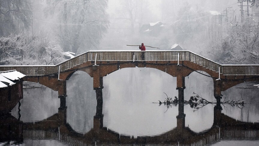
In the Himalayan ranges of Indian-administered Kashmir, glaciers that have sustained ecosystems and human life for centuries are shrinking at an alarming pace.
Home to more than 12,000 glaciers, the region’s ice lies in remote, high-altitude terrain, which has traditionally made monitoring difficult.
Scientific evidence shows that rising temperatures, shifting precipitation patterns and human activity are accelerating glacier retreat, with the Himalayas warming faster than the global average.
Amid these changes, scientists are turning to artificial intelligence (AI) to better understand – and potentially mitigate – the crisis.
From satellite-driven algorithms to predictive flood models, AI is transforming glacier science in one of the world’s most remote and climate-vulnerable regions.
“Artificial intelligence is a game changer. It allows researchers to pinpoint the exact status of glaciers and can inform early warning systems and detection of underlying risks,” Irfan Rashid, professor and head of the Department of Geoinformatics at the University of Kashmir, told Anadolu.
Rashid, who has led several cryospheric monitoring studies in the region, is working with AI-based models and satellite datasets to improve mapping of glaciers, glacial lakes and permafrost.
“AI can detect patterns in climate, snow cover and ground surface temperature to predict where permafrost is likely to occur, even in remote and data-poor regions,” he said.
In one study, Rashid examined the Kohalai Glacier – often referred to as the “water tower” of Kashmir – and found that it has lost nearly a quarter of its surface area over six decades. Its snout, the glacier’s lowest point, has retreated by approximately 900 meters (2,950 feet) since 1978, reflecting a broader regional trend.
These findings align with wider Himalayan research.
A 2019 study published in Science Advances found that glaciers in the region have been losing ice at twice the rate since 2000 compared to previous decades.
Up to one-third of Himalayan glaciers could disappear by 2100 even if global warming is limited to 1.5C (2.7F), according to the International Centre for Integrated Mountain Development.
Rising risks and expanding lakes
One of the most immediate consequences of glacier retreat is the rapid formation and expansion of glacial lakes.
A long-term regional study recorded an increase in such lakes from 253 in 1990 to 324 in 2018, underscoring both accelerated melting and rising risks.
These lakes can trigger Glacial Lake Outburst Floods – sudden and potentially catastrophic events capable of devastating downstream communities.
Across the broader Himalayan region, nearly one million people are estimated to live near high-risk lakes.
“Glacial lakes form naturally, but they require careful monitoring and management,” Khalid Murtaza, professor and researcher at the University of Kashmir, told Anadolu. “Risk factors must be identified early to prevent disasters.”
Recent research highlights the growing role of AI in this field.
Machine learning techniques, including convolutional neural networks and random forest models, are increasingly used to map glacier boundaries, detect ice loss and identify glacial lakes using satellite data.
Studies in the Indian Himalaya show that AI-based models significantly improve both the speed and accuracy of glacier and lake detection compared to traditional methods.
Indeed, one of AI’s most promising applications lies in forecasting cryosphere-related hazards.
By combining satellite imagery with climate and ground-based observations, AI models can identify unstable glacial lakes and simulate potential flood scenarios.
These systems are increasingly seen as central to early warning networks in vulnerable mountain regions.
International research efforts – including those supported by organizations such as Glacier and Permafrost Hazards in Mountains, NASA and the European Space Agency – show that AI-driven models can significantly improve the accuracy of predictions related to glacier melt and associated risks.
For Kashmir, where rivers depend heavily on glacier-fed flows, such predictive capabilities could prove critical for both disaster preparedness and long-term water security.
Kashmir’s labs go digital
At institutions such as the University of Kashmir, scientists are combining traditional fieldwork with advanced computational tools.
By integrating satellite imagery, in situ observations and climate datasets, researchers are tracking long-term changes in glacier structure, mass balance and movement.
“Field observations remain essential, but AI-powered remote sensing is helping bridge critical data gaps,” researcher Tariq Abdullah told Anadolu.
“In mountainous regions like Kashmir, where access is often limited, these tools are invaluable,” he added.
The retreat of major glaciers is already affecting irrigated agriculture, biodiversity and freshwater availability.
Scientists warn that continued ice loss could also significantly alter river systems that sustain millions of people downstream.
Globally, similar approaches are gaining traction. Studies published in journals such as Remote Sensing of Environment and The Cryosphere demonstrate how AI-assisted remote sensing can monitor glacier dynamics, forecast melt rates and assess future water availability.
“AI is not a solution on its own,” Rashid said, “but it is becoming a crucial tool – helping researchers move faster, see deeper and plan better in the face of a changing climate.”